![]()
Wikipedia describes AIS as follows
The Automatic Identification System (AIS) is an automatic tracking system used on ships and by vessel traffic services (VTS) for identifying and locating vessels by electronically exchanging data with other nearby ships and AIS Base stations. AIS information supplements marine radar, which continues to be the primary method of collision avoidance for water transport.
Information provided by AIS equipment, such as unique identification, position, course, and speed, can be displayed on a screen. . AIS is intended to assist a vessel's watch standing officers and allow maritime authorities to track and monitor vessel movements.
If you are sailing mainly in sheltered waters, away from commercial traffic, then you really don't need it - but if you sail in areas where there are many ships, then in fog or at night, it can be a life saver. A couple of times recently we were sailing in the Gibraltar Strait area and unexpectedly ran into thick fog. Whilst our Radar and MARPA (mini-automatic radar plotting aid) showed clearly the tracks of ships around us, and those on possible collision course with us, there was no easy means of identifying them by name thus making VHF contact difficult and unreliable.
Having been badly scared by a couple of close encounters both in fog and at night, we decided to fit AIS (Automatic Identification System).
The web sites below show active AIS all round the world and you can see exactly how it works, and how easy it is to get in touch with vessels who could cause a threat in difficult conditions.
http://www.marinetraffic.com/ais/
What I have gained by installing a AIS transponder is this:
Sailing or motoring, particularly at night or in fog, I can see the course and track of all vessels over 500 tons in my vicinity. If I am concerned about the proximity of one, I can 'highlight' them, and the system will tell me their course, speed and if we are on possible collision courses and how long to that happening.
If I then decide that I should communicate with the other vessel I have their ships name, call-sign displayed so there can be no ambiguity as to whom I am calling on VHF.
Equally important is the other vessel can 'see me' on his screen and identify a sailing boat. The other vessel can contact me, as my call sign and name are displayed. If I call then the officer of the watch knows which, of perhaps several small boats displayed on his system, I am.
There are two options for small vessels, assuming you will not be fitting a 'Class A' commercial AIS system, which is serious money and whilst being far more powerful = longer range = are not really for pleasure craft.
The first option is a transceiver/transponder which receives the AIS signal from other AIS stations and transmits your AIS identification back to other craft. This has the advantage that when you call up a 'big ship' they will see your vessels name, course speed etc on their own AIS screen and know which, of perhaps several small craft showing on their radar/AIS, they are talking to. The cost of this system 'class B transceiver is around £800 with the required VHF antenna.
A couple of examples below:
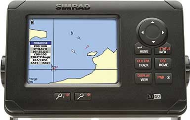
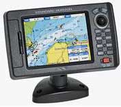
 Simrad AI50 class B
AIS transponder
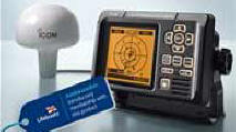 Icom MA-500TR
AIS Transponder

I purchased the Simrad A150 as it has a colour screen, I find the display pleasing, and because I wanted it in front of the helm so it needed to be waterproof. Not only will it display the call sign and name of the other vessels, it will provide the course and speed, lat & long and if it is on a collision course with you and when that will happen. You can also put in guard zones and closest permitted passing distance. It has a world map built in showing all the coastlines.
---------------------------------------
The alternative are the 'passive' types of AIS which of course are much cheaper but do not let the 'ship' you are calling know which, of all the pleasure boats it has on it's radar, is you,,,, It comes in various forms with either their own display or via your laptop in the boat. You will still need a dedicated GPS antenna and a VHF antenna which are not included in the price shown below.

Nasa AIS Radar
requires GPS antenna or splitter
 Clipper AIS Enginee 3Nasa
AIS Engine 3
(requires a laptop)
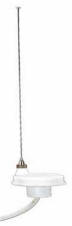
XM Yachting ST/STEEL MASTHEAD ANTENNA AIS
To call the NASA a radar is hyperbole - Radar is something which enables you to be out in zero visibility with some degree of safety. It will also show vessels of less than 500 tons, buoys, land, objects in the sea. AIS is only required on vessels of over 500 tons and bits of land or other hard stuff will not show up. I get the impression with these two NASA / AIS you need a GPS feed and an a VHF antenna. (With the Simrad and Icom they supply the GPS antenna but not the VHF antenna.
(Technical details of all of the above are at the bottom of this page.)
THE FUTURE
I am fairly certain that if you are in the market for a new chart plotter or new radar, it will come with a built in AIS transponder, still requiring GPS and VHF antenna as extras but none the less is of course the perfect solution. Whilst most radar systems have had MARPA (mini-automatic radar plotting aid) for years, I suspect most of this and the next generation will have AIS built in as standard.
I installed the Simrad A150 myself, which took most of the day. the hardest part being the cable run and finding a nice bit teak to mount the display in front of the wheel.
Normally I turn the chart plotter off, once we are out at sea, and tend to rely on the GPS display and in poor visibility on the radar. Now I will have the important, additional information, from the AIS in front of me.
For almost all the Transponder type AIS you need to install a GPS antenna which they supply with the receiver as well as a VHF antenna or splitter.
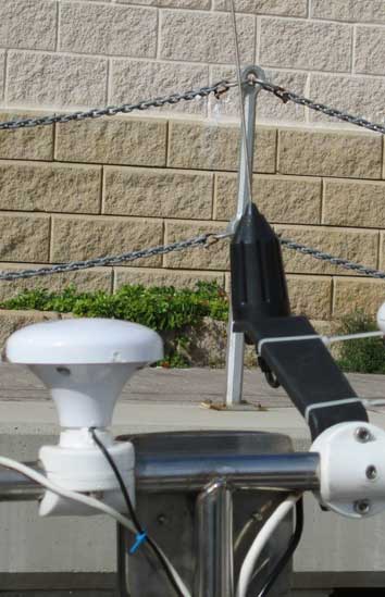
I have a pole with a T on the top, mounted on the stern of. On it is the Navtext antenna, the Raytheon system GPS antenna and the stern light - (the lower one being masked by the dinghy when it is on the davits.) To the above I added the GPS antenna supplied by Simrad and the XM yachting antenna that was reccomended for the SIMRAD AIS system.
The GPS antenna on the left came with the Simrad and the VHF antenna is a XM Yachting ST/STEEL MASTHEAD ANTENNA AIS which did not come with the kit..
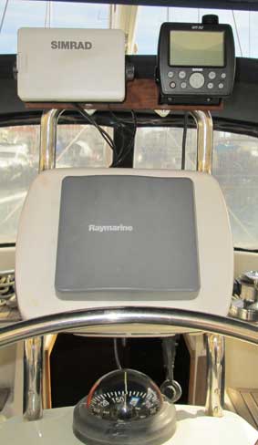
Displayed above the helm is the Simrad AIS, the GPS and the Radar/Chart plotter not to mention the compass which is almost certainly driven crazy by all the electronics around it but none the less useful. I have yet to have a season with the new Simrad AIS but I am optimistic it will be invaluable and make contacting large vessels much easier.
All the above is just my opinion - if you think I am wrong or want to add to the article please email me - here
scroll down for technical details of AIS mentioned above
For my sailing books and French canal guides please go to


The prices mentioned are circa 2015 and are for comparison.
£120
Clipper AIS Engine 3Nasa
AIS Engine 3
- The AIS Engine 3 & a conventional VHF antenna are all you need to start
plotting vessels on your PC or AIS compatible plotter. The unit can receive
ships on either the A or B AIS channels. The software includes a world map on
which vessels are plotted. Any vessel on the screen can be selected & its AIS
data displayed. Also included is an optional input for a GPS, to allow the users
own vessel to be shown on the chart with its lat and long displayed.
• Operating frequencies: 162.025 & 161.975 mHz • 12Volts • Size: 115x100x30mm •
NMEA RMC from GPS • Antenna input: 50 ohm BNC (To connect to the VHF antenna you
may need a BNC to PL259 Adaptor)
• Supplied with Software, fused power cable and a data cable to connect to the
9pin serial port of a PC.
Receive AIS data on your PC or AIS compatible plotter Supplied with free copy of 'Sea Clear' and a trial version of Software on Board. Windows compatible software includes a world map on which vessels are plotted. Any vessel on the screen can be selected and its AIS data displayed. Can be used with plotters or other compatible PC software that have an AIS input facility
£741
Simrad AI50 class B AIS transponder
the Simrad AI50 class B AIS transponder offers boat owners the most exciting new development in the safety of navigation. - Be In Control - Avoid Collisions At Sea - The Simrad AI50 AIS transponder offers boat owners the most exciting new development in the safety of navigation. Now Simrad Yachting is introducing the first compact Class B AIS with a color display. The class B standard offers all the visibility and benefits of the class A without the complications. The result is that AIS is now affordable for all users. Mounted at the helm, the Simrad AI50 offers unsurpassed simplicity of operation and clarity of information. Blind Spots & Large Waves - With radar antennas mounted high above sea level, smaller vessels can remain undetected below the beam, mistaken as waves or lost in vessel blind spots. - Identification With Blocked View - With Simrad AI50 you can see or trace other vessels equipped with AIS Transponders, even in the dark, or when the radar's line-of-sight is blocked. Vessel information at a glance AIS (Automatic Identification System) comes into its own when the helmsman cannot see the position of the other targets around him. Vessels may be tracked and their CPA and TCPA calculated, offering the helmsman ample warning of impending close approach or dangerous situation. - Enter the MMSI numbers of friends and regular contacts, also fitted with AIS, into your Favorites list. As soon as a listed vessel sails into the view of your Simrad AI50, you will be alerted to its presence. This valuable feature will be of great benefit to flotilla operators, racing sailors, fishermen, and even commercial operators. - Bracket or Flush Mounted? The new design allows the Simrad AI50 to be easily flush mounted, standing or hanging from the supplied bracket. - Calculates Closest Point of Approach - Calculates Time to CPAThe selected vessel's present Course - The selected vessel's current Heading - The selected vessel's current Rate of Turn - Backlighting LED Red or White - Display Type VGA TFT 102mm (4in) « less
£770
Icom MA-500TR AIS Transponder
This dual-channel AIS
Transponder allows you to receive AIS information and display it on its clear
full dot-matrix display as well as transmitting your data to other vessels in
your area. • Display shows real-time vessel traffic information • Screen Size:
62.25mm x 62.25mm • 2W output • Waterproof (IPX7) • 3 lines of NMEA0183
Input/Output • Collision-risk management functions & alarm • Target list &
dangerous list • DSC button - call a selected vessel instantly • External alarm
connection • Receives AIS signals on Ch.87B (161.975NHz) & Ch.88B (162.025MHz)
simultaneously • GPS receiver data input port for multiplexing GPS & AIS data.
Includes: AIS Transponder (main unit), GPS
Antenna with 10m cable, Mounting bracket, DC power cable, NMEA
connector cable.
Standard Horizon CP-180i Plotter Internal Antenna
£324.95
Standard Horizon CP-180i Plotter Internal
Antenna
The CP180 is a high quality compact colour chartplotter with a
clear, crisp 5in sunlight view TFT display. Despite its compact
size you can benefit from the advanced features of the very
latest C-Map MAX enhanced cartography. Available with internal
or external antenna. The added safety feature of AIS integration
means the CP180 can offer vessel position overlay directly onto
the chart and you can display vessel information such as course,
speed, destination, number of passengers etc (external AIS input
required). Features: C-Map MAX and NT+ compatible • Customisable
data windows • 2nm worldwide basemap • VHF DSC polling
capability • 3 NMEA outputs & 2 inputs • Display: 320 x 240
pixels • Dimensions: W181xH111xD44mm • User Points
(Marks/Waypoints): 600 • Routes: 20 (max 30 Waypoints each) •
Trackpoints :3000 (recordable in 5 Tracks) • Swivel mounting
bracket & flush mount kit included
£220
Nasa AIS Radar
Nasa AIS Radar - All ships over 300 tons & all passenger
carrying vessels have to carry the Automatic Identification System (AIS), a VHF
transponder system sending data identifying the ship, its name, position, speed,
course and heading and MMSI number.
The Nasa AIS radar receives the transmissions from AIS transponders and displays
the information on a radar like display. Linked to your boat's GPS, it puts your
boat in the centre of the screen allowing you to see instantly a vessels
relative position and bearing to yourself.
Simple to install, it requires a 12V supply, GPS input, and connection to a
dedicated VHF aerial. This may require an adaptor (see product code: 230060)
• Tracks up to 30 vessels
• Uses standard Marine VHF antenna
• Backlit display
• Consumption: 50mA @ 12V (100mA with backlight)
• Size: W150 x W112 x D42mm.
SeaTraceR Combo VHF/Active GPS Antenna £139.95
XM Yachting ST/STEEL MASTHEAD ANTENNA AIS
£61.00
![]()
![]()
![]()
![]()
![]()
![]()
![]()
![]()
![]()
![]()
![]()
![]()
![]()
![]()
![]()
![]()
![]()
![]()
![]()
![]()
![]()
![]()
![]()
![]()
![]()
![]()
![]()
![]()
![]()
![]()
![]()
![]()
![]()
![]()
![]()
![]()
![]()
![]()
![]()
I am pleased to say this web site is

who have been kind, helpful and understanding. I really recommend them
Click here to purchase web hosting with HOST 100