|
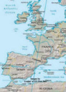
Routes Between the English Channel and the Mediterranean |
|
|

|
SN2 FROM UK TO HALF WAY DOWN BISCAY AND THE CANAL DU MIDI TO THE MEDITERRANEAN north to south via Canal du Midi This book has full details
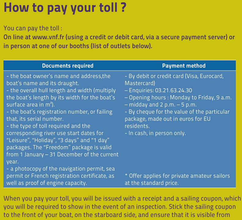
At some point you will have to buy a license for the time spent in the river canal system - fairly inexpensive VNF- Check on the official web site http://www.vnf.fr for info on closures works and all information - the French site works better than the English. Best time May to September early October - but of course the Canal du Midi section can be done at any time (*unless it freezes or there is a drought) This route takes you into the Gironde River just south of La Rochelle and past Royan up the river to Bordeaux where take down you mast and use the Canal du Midi to take you down to the Mediterranean coming out near Marseille at Port St Louis or Sete. As in route NS1 you can sail direct to Royan/entrance of the Gironde from the English channel DISTANCE Falmouth to Royan - 355 nautical miles - 3 days or less (It is perfectly possible to day sail this from the UK the only challenging bits being possibly the Chenal du Four and around the Channel Islands. From Camaret you can day sail to Royan.) At Bordeaux you take down your mast and get lots and lots of fenders or rubber tyres to surround you topsides and protect your hull from the rough concrete walls that you will regularly be coming alongside in locks. The tyres should touch the water.... It may be worth making a couple of X's out of wood with a bolt through to support the mast before you leave the UK - there are normally stacks of tyres at the cranes left by boats going the other way. NOTES ON THE CANAL DU MIDI. Biggest problems Draft - 1.6 metres (5ft 2 inches) MAX! Less in high summer - Width 5.5 metres - (18ft.) Height 3 metres, but be warned that the height of 3m is to the centre of the bridge arches - the sides may be as low as 2metres (6ft 5inches) The length of the locks is 30metres (98ft 4inches) So although this can be a good route for many, the very low bridges with an arch may be a problem.... Also be aware that in mid summer when there is a drought, water can be lower than advertised in the Canal du Midi. Unlike the canals in eastern France where you can push your keel though the soft mud the Canal du Midi was blasted out of rock... It is not unknown for boats on the limit to have to be craned out and put on lorries when the level drops in mid summer. DISTANCE FROM Bordeaux to Sete - 503 Kilometers - 139 locks. Canal du Midi = My log and some pictures of a recent transit. The actual Route is the Gironde into Bordeaux and then into the Garonne to Castets - about 53K from Bordeaux. From there it becomes the Canal Lateral a la Garonne to Toulouse where it becomes the Canal du Midi. At Sete or Port St Louis you can get your mast re-stepped get rid of your tyres and you are already half way across the Mediterranean. Not too far from the Balearics or Corsica and Italy. You need a proper detailed chart of the Gironde between Royan and Bordeaux - like the Thames estuary, this is a serious river with shoals and fast running currents. For information about closures - repairs and maintenance work visit http://www.vnf.fr which is the River and Canals authority official web site. It is in English and French. Some of the English pages do not always work or have not been updated so try and struggle with the French version if that's the case. SN1 = north to south - direct route by sea SN2 = north to south via Canal du Midi SN3 = north to south via Le Havre - Paris - or Calais or St Valery SN4 = south to north via Atlantic coast SN5 = south to north via Azores SN6 = south to north via Canal du Midi SN7 = south to north via canals to Paris and Le Havre or Calais Lorry option = a list of web sites of British and French haulage companies who specalise in boat transport. Canal du Midi = My log and some pictures of a recent transit. (SN7) The Scenic Route = My log and some pictures of a recent transit. (SN6) Some canal tips 1. Take off your masthead light, wind vane and vhf antenna - put a bucket over the top of the mast to protect it - they always seem to get bashed. 2. You will need 2 lines to each tyre fender (by law) As you will need as many as possible buy some cheap nylon rope to fix the 'fenders' as you will probably not have enough short lengths in the locker. 3. Keep a knife available in the cockpit just in case one of the mooring lines gets snagged and hangs the boat up as the water goes down in the lock. 4. If you are short handed (only 2) and you have a long enough line - fix a block on the bows and lead the fwd warp through the block and back along the deck to the cockpit - that way who ever is in the cockpit can pull in or let out the lines in the lock if the other one gets stuck on the lock side and is unable to get back on board. 5. You will need a hammer or preferably a mallet to hammer metal spikes into the bank to moor to at night. Frequently keel yachts can only get their bows close to the shore as the rivers/canals frequently shallow at the sides. 6. It may be worth considering having the mast taken by lorry to your destination - Certainly makes the trip easier in terms of moving around the boat. 7. At some point you will have to buy a license for the time spent in the river canal system - fairly inexpensive and check on the official web site http://www.vnf.fr for info. The license is based on the time you intend staying in the waterway system - by day/week/month/year. 8. Under European (and of course French) law anyone operating a boat on the European canal system is required to have a 'boat driving license' as issued by their own country of origin. You can travel in any European river or canal with only the license issued by your own authority. Catch 22 is that the British authorities do not require you to have one! Under the new French 1991 law you need a Certificate of Competence which is issued by the RYA. You may also pass the French test - cat C for boats less than 15m and slower than 20Km/h. Many sea boats do the transit without the certificate. NAVIGATION FEESLicence (Vignette) Fees 2022Navigation fees are simply based on boat length. The vignette certificate should be displayed at the front of the boat, on the starboard side.
This site has a series of tests for the written part of the CEVNI certificate http://www.sailtrain.co.uk These
web sites may be useful for the end of the canal system in the http://guidemediterranee.free.fr/article.php3?id_article=0301
|
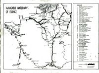 Click
here for canals chart
Click
here for canals chart
|
|