|
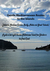
Routes Between the English Channel and the Mediterranean |
|
|
|
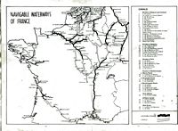
Routes Between the English Channel and the Mediterranean south to north via canals to Paris and Le Havre, or from Calais, St Valery sur Somme.
SN7 = South to North From the Mediterranean via canals and rivers to Paris and Le Havre or Calais & St Valery sur Somme With out a doubt this is the nicest and most memorable route from the Mediterranean to the UK - I have done it in both directions and remember it as a delightful experience. I have done the Atlantic route and found it quite hard work going to windward almost all the time. I have done the Canal du Midi route but it still leaves windward work after you get to Bordeaux. If you are heading to the UK this is the most enjoyable route by far in my experience. It is possible to do this route in just over 2 weeks if you move every day and do a minimum of 8 hour days.. Hard work but possible if you are in a hurry...... BEST TIME - almost any time of year is possible but IN WINTER the canals can freeze making progress impossible. There are few marinas or places with shore power so you need your own heating system in the boat. The river sections of the route can be subject to flooding in late summer or winter. Crossing the English channel in winter is really a matter of warm enough clothes and waiting for the weather but should be treated seriously - Always possible to leave the boat in France - French marinas on the channel coast are less than half the price of English marinas.
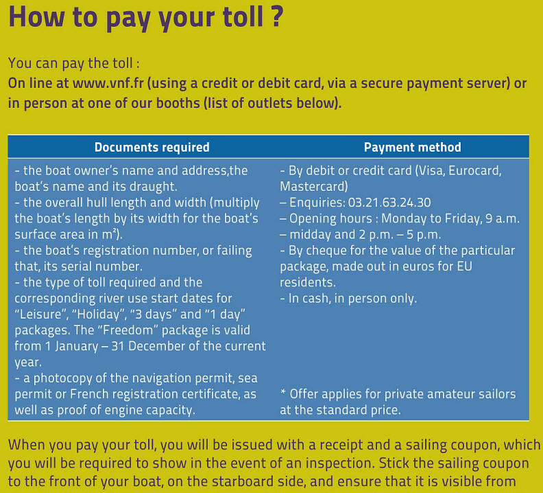
NOTES ON THE CANALS Draft = 1.8 metres - 5ft 9inchs. Beam = 5 metres - 16ft 4inches. Height = 3.5 metres - 11ft 4 inches. The above are for the main canals and rivers from the Mediterranean to Le Havre. There is a tunnel in on the canal du Bourgogne with a height of 3.1 metres and the canal du Nivernais has a max draft of 1.2 metres but there is no reason to use these unless exploring...) I have only listed the direct routes from the Mediterranean to the channel ports. There are many more canal cruising routes if you want to do that. There are basically 4 entry points to the canal system on the Mediterranean coast of France - Port St Louis, Sete, Port La Nouvelle and Agde - the last two have lower drafts (can be as little as 1.20Ms) than Sete or Port St Louis. Port St Louis now has a marina and all faculties. Take down your mast and get lots and lots of fenders or rubber tyres to surround you topsides and protect your hull from the rough concrete walls that you will regularly be coming alongside in locks. The tyres should touch the water.... It may be worth making a couple of X's out of wood with a bolt through to support the mast.- there are normally stacks of tyres at the cranes left by boats going the other way. Covering them in plastic rubbish bags secured with lots of sellotape and constantly renewed is helpful in keeping black marks off the hull. At some point you will have to buy a license for the time spent in the river canal system - fairly inexpensive and check on the official web site http://www.vnf.fr for info. Sometimes the English part does not work to well and the French is frequently more up to date.... NAVIGATION FEESLicence (Vignette) Fees 2022Navigation fees are simply based on boat length. The vignette certificate should be displayed at the front of the boat, on the starboard side.
When you are ready to set off you lock out of the yacht basin into the Petit Rhone - at this point it is 321Km to Lyon and the end of the Rhone. Both Arles and Avignon are well worth a visit even though they are a little off the direct route - shame to miss them. This river has been tamed by its 12 locks and generating barriers not to mention the huge nuclear power facilities. Its advertised rate is 4 knots and can be less but you go up stream slowly. The locks are vast. Moor your boat to a single floating bollard and hold very tight - if you are more or less alone in the lock the turbulence can be significant. If the Mistral is blowing conditions can be dangererous - I have turned back and returned to my mooring having shipped it green over the bows! You are in big ship territory and they are constrained by their draft. - It will probably take a minimum of 4 days to get to Lyon. A chart or pilot book is essential. You can park up in the centre of Lyon having left the last lock of the Rhone and relax - no more giant locks - A beautiful city and you are now in the River Saône - 142 Km to go to Chalon where you hang a left into the smaller Canal du Centre. The river Soane is beautiful. Chalon has a big yacht harbour with all facilities H2O. Some 112km later and 61 locks later - this is about half way - at Dignon, you join the Canal Lateral a la Loire which goes to Briare - only 37 locks in 103Km in this section. At Briare you enter the Canaux du Loing (103 Km and 50 locks = 1 every 2 hours or so and each lock will take between 30 and 60 minutes depending on how long you have to wait to enter..) and head for St Mammes. At St Mammes you enter the upper reaches of the Seine. Only 7 locks in 87Km so progress is much faster. You end up in Paris - the most wonderful way to see this city - from the river Seine. There is a boat marina you can lock into right in the centre - Paris-Arsenal Marina. After Paris the river becomes very tidal- there are some fast flowing currents and a proper chart or pilot is essential - You can put the mast up again at Rouen in the boat yard. Activité plaisance Lamanage Rouen Tél : 02.32.10.26.57 Fax : 02.35.70.52.37 activiteplaisance@lamanage-rouen.fr At the mouth of the Seine you can go into Honfleur or Le Havre to re-step your mast. I prefer Le Havre because you are in the centre of the city and you can leave at any state of the tide for the channel ports.... Dump your tyre fenders by the crane for the next boat that wants to head south - check the electrics and your off..... You need the following Navicarte or similar publications #1 = La Seine aval - le Havre to Paris #2 = La Seine amont - Paris to St Mammes - short section and if you have another general guide you could possibly get away with that? #6= Canaux du Centre (includes the canal du Brise, Lateral and Loir as well - its really just one route) #10= La Saone #16 = Le Rhone which takes you to both Port St Louis and to Sete. Routes SN1 = north to south - direct route by sea SN2 = north to south via Canal du Midi SN3 = north to south via Le Havre - Paris - or Calais or St Valery SN4 = south to north via Atlantic coast SN5 = south to north via Azores SN6 = south to north via Canal du Midi SN7 = south to north via canals to Paris and Le Havre or Calais Lorry option = a list of web sites of British and French haulage companies who specalise in boat transport.
The St Valerie & Calais Options: There is an option just after Paris of taking a route to St Valerie sur Somme and Abbville - you would need to buy Navicarte #24 Picardie.St Valery is situated half way between Calais and Le Havre and is another possible way of getting into the English Channel. Unlike Le Havre and Calais which can be used at any state of the tide St Valery has extensive shoals and at LW neaps will dry - you need the appropriate chart or pilot and a rising tide - having said that it is well buoyed. There is a good marina at St Valery to re-mast. The sea locks opens roughly 1 hour either side of HW and lets you out the Canal de la Somme (lots of WW1 connections and memorabilia) and into the tidal marina. For Calais + alternative to St Valerie. Follow the Rhone and Soane as indicated above but do not turn left into the Canal du Centre. Instead continue up the Soane towards St Symphorien turning left into the Canal de la Marne a la Soane for some 225 Km and 114 locks (a lock every couple of hours!) Slows you down a lot but improves your boat handling skills! (NOTE - at the end of the Canal de la Marne and Soane it is possible to get to St Valerie via the canal de la Somme) For Calais you take the Canal de l'Oise a l'Aisne for 48Km, 13 locks and 1 tunnel of 2.5Km to Chauny. From there its the Canal de l'Oise a l'Aisne for 48 Km and 13 locks and one tunnel of 2.5Km From Chauny you head for Aire via the Canal de St Quentin, River Escauit, the Canal de la Sensee, the Canal de la Deule and finally the canal d'Aire.- 178 Km 42 locks and two tunnels one of just over a 1Km and the other 5.6Km - you have to be towed though this one and 'tows' are assembled twice a day in each direction and you have to pay a fee - it takes at least a couple of hours. Next is the Canal de Neufosse from Aire 18Km + 2 locks, Canal de la Colme to Watten and into the River Aa. Then You then pass through 5 automatic lifting - swing bridges and 1 lock operated by rods (VHF 10 if problems) Then into the Canal de Calais. Pontoon mooring whilst you wait for the Ecluse Canot to open and let you into Calais harbour and the marina in order to re-step your mast and dump your tyre fenders. The Navicartes you will need for these route variations are: #14 = Nord Pas de Calais #24 = Picardie #8 Champagne-Ardenne #10 La Soane #16 la Rhone.
|

|
Canal du Midi = My log and some pictures of a recent transit. (SN7) The Scenic Route = My log and some pictures of a recent transit. (SN6) SN1 = north to south - direct route by sea SN2 = north to south via Canal du Midi SN3 = north to south via Le Havre - Paris - or Calais or St Valery SN4 = south to north via Atlantic coast SN5 = south to north via Azores SN6 = south to north via Canal du Midi SN7 = south to north via canals to Paris and Le Havre or Calais Lorry option = a list of web sites of British and French haulage companies who specalise in boat transport. Canal du Midi = My log and some pictures of a recent transit. (SN7) The Scenic Route = My log and some pictures of a recent transit. (SN6) Parking Places in the Rhone = A list of the relatively few possibilities to overnight in the Rhone. VNF = Voies Navigables de France - details of license fees and canal offices - official paper http://www.sailtrain.co.uk/cevni/images/cevni1.htm This site has a series of tests for the written part of the CEVNI certificate find out if you know the rules! Probably the best site for learning boating things on the net! Some canal tips 1. Take off your masthead light, wind vane and vhf antenna - put a bucket over the top of the mast to protect it - they always seem to get bashed. 2. You will need 2 lines to each tyre fender (by law) As you will need as many as possible buy some cheap nylon rope to fix the 'fenders' as you will probably not have enough short lengths in the locker. 3. Keep a knife available in the cockpit just in case one of the mooring lines gets snagged and hangs the boat up as the water goes down in the lock. 4. If you are short handed (only 2) and you have a long enough line - fix a block on the bows and lead the fwd warp through the block and back along the deck to the cockpit - that way who ever is in the cockpit can pull in or let out the lines in the lock if the other one gets stuck on the lock side and is unable to get back on board. 5. You will need a hammer or preferably a mallet to hammer metal spikes into the bank to moor to at night. Frequently keel yachts can only get their bows close to the shore as the rivers/canals frequently shallow at the sides. 6. It may be worth considering having the mast taken by lorry to your destination - Certainly makes the trip easier in terms of moving around the boat. 7. At some point you will have to buy a license for the time spent in the river canal system - fairly inexpensive and check on the official web site http://www.vnf.fr for info. The license is based on the time you intend staying in the waterway system - by day/week/month/year. 8. Under European (and of course French) law anyone operating a boat on the European canal system is required to have a 'boat driving license' as issued by their own country of origin. You can travel in any European river or canal with only the license issued by your own authority. Catch 22 is that the British authorities do not require you to have one! Under the new French 1991 law you need a Certificate of Competence which is issued by the RYA. You may also pass the French test - cat C for boats less than 15m and slower than 20Km/h. Many sea boats do the transit without the certificate. NAVIGATION FEESLicence (Vignette) Fees 2022Navigation fees are simply based on boat length. The vignette certificate should be displayed at the front of the boat, on the starboard side.
http://www.sailtrain.co.uk/cevni/images/cevni1.htm This site has a series of tests for the written part of the CEVNI certificate find out if you know the rules! Probably the best site for learning boating things on the net!
These
web sites may be useful for the end of the canal system in the http://guidemediterranee.free.fr/article.php3?id_article=0301
|
|
|
|
I am pleased to say this web site is
who have been kind, helpful and understanding. I really recommend them |