|
Routes Between the English Channel and the Mediterranean |
|
This is the excellent company I use:
|

|
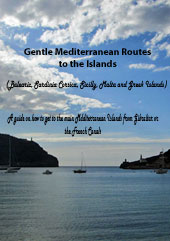
The alternative to the Gentle Route is to do it in fewer hits as follows north to south - direct route by sea SN1 THE DIRECT ROUTE FROM THE UK ACROSS THE BAY OF BISCAY AND DOWN ATLANTIC SPAIN AND PORTUGAL
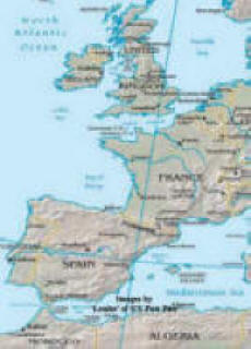
The direct route across the Bay of Biscay. - Best time - May to September early October - Possibly the hardest part of this route is getting down channel against the prevailing westerly winds to Falmouth, Fowey, or the Scilly Islands ready to jump off the moment the wind is forecast to turn northely for the next five days. From the English channel go outside Ushant/Ouessant but just inside the shipping lanes and lay course for just inside the shipping lane off Cape Finisterre. From Finisterre head south. A very good place to pull into is Bayona near Vigo. Beautifully sheltered bay and excellent marina and yacht club. DISTANCE FALMOUTH TO BAYONNE - 542 nautical miles - say 4 to 5 days - non stop From Bayonne you can get to the Straights of Gibraltar in one hit easily with the prevailing Northerly winds or stop on the way down - Lots of ports, anchorages and marinas. DISTANCE BAYONNE TO GIBRALTAR - 510 nautical miles - say 4 days - non stop Biscay rightly has a formidable reputation for gales in winter but in the summer it is fairly benign. By getting a 4-5 day forecast before committing it is reasonable to expect to reach Bayonne without problem. If you are pushed into Biscay bay then Coruna has easy access and an excellent anchorage and marina. Time for passage assuming a few stops between Bayonne and Gibraltar for weather/fun - 10 - 14 days It is perfectly possible to day sail nearly all of this route and almost never loose sight of land - many boats do this - all the way to Gibraltar - Heading first to the Channel Islands then north France - Morlaix area - inside Ushant/Ouessant and southwards. The longest single passage is from La Rochelle or Royan in France to Bayonne or San Sebastian - a 'hit' of around 170 miles the only possible stopping place is Arcachon and you must work the tide to get in there - and out. Probably take you all summer (or 2) to do this port hopping. |
Have a look at my BISCAY LOG BOOK for some of my experiences whilst making this passage. SN1 = north to south - direct route by sea SN2 = north to south via Canal du Midi SN3 = north to south via Le Havre - Paris - or Calais or St Valery SN4 = south to north via Atlantic coast SN5 = south to north via Azores SN6 = south to north via Canal du Midi SN7 = south to north via canals to Paris and Le Havre or Calais Lorry option = a list of web sites of British and French haulage companies who specialise in boat transport. Canal du Midi = My log and some pictures of a recent transit. (SN7) The Scenic Route = My log and some pictures of a recent transit. (SN6) Parking Places in the Rhone = A list of the relatively few possibilities to overnight in the Rhone. VNF = Voies Navigables de France - details of license fees and canal offices - official paper |
|
|